
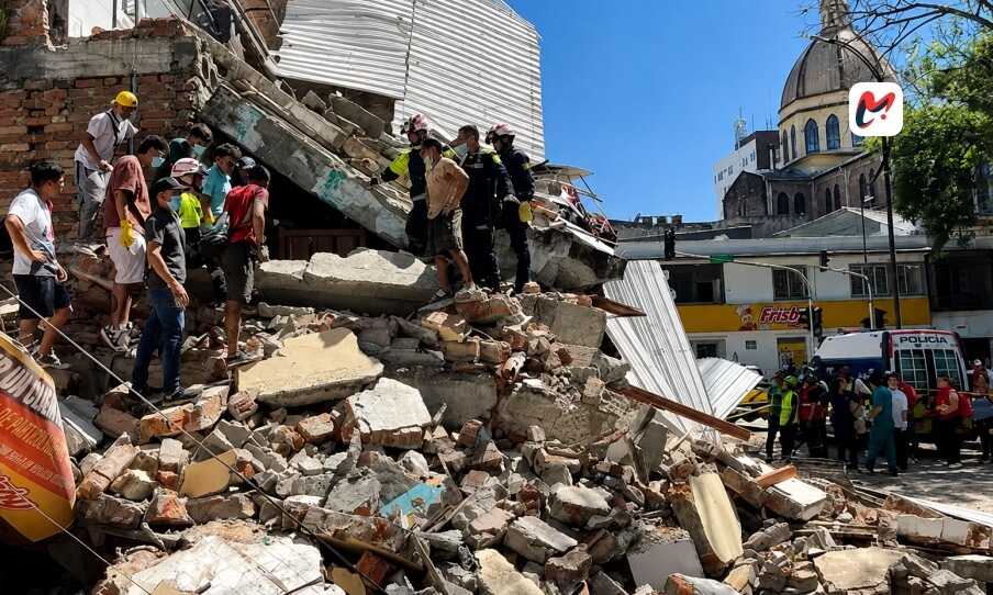
Earthquakes have long been an inseparable part of Colombia’s natural landscape. Stretching from the Caribbean Sea to the Pacific Ocean and crossed by the towering Andes Mountains, the country occupies one of the most geologically active regions on the planet. Every year, thousands of seismic events occur beneath Colombian soil. Most are too weak to be noticed, while others serve as stark reminders of nature’s immense power, disrupting lives, damaging infrastructure, and reshaping communities within seconds.
The devastating 7.4-magnitude earthquake that struck western Colombia on 10 August 2026 once again brought the country’s seismic vulnerability into global focus. The earthquake, the strongest recorded in Colombia during the 21st century, caused extensive destruction across several departments, damaging homes, hospitals, schools, highways, and public infrastructure. Rescue teams worked through the night searching for survivors as aftershocks continued to rattle affected regions. Initial reports confirmed more than one hundred fatalities, hundreds of injuries, and widespread displacement, prompting the government to declare a national emergency and mobilize international humanitarian assistance.
Yet this tragedy is only one chapter in Colombia’s long relationship with earthquakes. The country’s seismic activity is driven by powerful geological forces that have shaped its mountains, valleys, and coastlines for millions of years. Understanding these forces not only explains why earthquakes occur so frequently but also highlights why Colombia has invested heavily in earthquake monitoring, resilient infrastructure, and disaster preparedness.
This article explores the science behind Colombia earthquakes, examines the country’s seismic history, analyzes the significance of the 2026 disaster, and explains what the future may hold for one of South America’s most earthquake-prone nations.
Why Colombia Experiences Frequent Earthquakes
Unlike many parts of the world where earthquakes occur only occasionally, Colombia exists within an exceptionally dynamic geological environment. Beneath the country’s diverse landscapes, massive tectonic plates are constantly moving, colliding, and sliding past one another. Although these movements are measured in mere centimeters each year, they generate enormous pressure deep within the Earth’s crust. Over time, that pressure accumulates until the surrounding rocks can no longer contain it. The sudden release of this stored energy produces seismic waves that we experience as earthquakes.
Colombia’s geological complexity stems from its location at the meeting point of several tectonic systems. The South American Plate forms the continental foundation of the country, while oceanic plates beneath the Pacific Ocean continue to move toward it. Their interaction has shaped not only Colombia’s mountain ranges but also its long history of earthquakes and volcanic activity.
The movement of these plates is continuous and unavoidable. Unlike storms or floods, earthquakes cannot be prevented because they originate from natural processes occurring dozens of kilometers beneath the Earth’s surface. Scientists can identify areas where seismic activity is most likely, but accurately predicting the exact time, location, and magnitude of a future earthquake remains beyond current scientific capability.
For Colombia, this means seismic activity is not an occasional anomaly but an ongoing geological reality that influences urban planning, engineering standards, emergency management, and public safety.
Colombia’s Place Along the Pacific Ring of Fire
One of the primary reasons Colombia experiences frequent earthquakes is its position on the Pacific Ring of Fire, the world’s largest and most active seismic belt.
Encircling the Pacific Ocean, the Ring of Fire extends through Asia, Oceania, and the western coast of the Americas. It is responsible for the overwhelming majority of the planet’s largest earthquakes and hosts hundreds of active volcanoes. Countries such as Japan, Indonesia, Chile, Mexico, Peru, New Zealand, and Colombia all share the challenges associated with living within this highly active geological zone.
For Colombia, the Pacific coastline represents one of the country’s most seismically active regions. Here, dense oceanic crust gradually descends beneath the continental crust through a geological process known as subduction. Although this movement occurs slowly over geological timescales, the immense friction created between these plates stores tremendous amounts of energy. When that energy is released, it can produce earthquakes capable of affecting entire regions.
The same tectonic process has also contributed to the formation of Colombia’s volcanic landscapes, particularly within the Andean region. As oceanic crust sinks deeper into the Earth’s mantle, rising magma fuels volcanic systems that further illustrate the country’s extraordinary geological activity. Earthquakes and volcanoes, therefore, are closely connected expressions of the same underlying tectonic forces.
The Geological Forces Beneath Colombia
Although the Pacific Ring of Fire provides the broader context, Colombia’s seismic behavior is influenced by several overlapping geological systems that make its earthquake patterns particularly complex.
The Andes Mountains, which divide into three separate mountain ranges as they cross Colombia, are intersected by numerous active fault lines. These faults accumulate stress over time and periodically release it through earthquakes. Some originate at shallow depths, producing intense ground shaking near the surface, while others occur much deeper underground and are felt across large portions of the country.
One of the most fascinating seismic regions in the world lies beneath northeastern Colombia near Bucaramanga. Known internationally as the Bucaramanga Seismic Nest, this area experiences thousands of earthquakes every year, making it one of the planet’s most active concentrations of deep-focus seismic events. Most of these earthquakes are too weak or too deep to cause damage, but they provide scientists with valuable insights into the movement of tectonic plates beneath northern South America.
Adding further complexity, Colombia’s seismic activity is not generated by a single fault or plate boundary. Instead, multiple tectonic interactions occur simultaneously across different parts of the country. This explains why earthquakes can occur along the Pacific coast, within the Andes, or across inland regions separated by hundreds of kilometers.
The result is a seismic landscape where earthquakes vary considerably in depth, magnitude, and impact. Some produce violent local shaking despite moderate magnitudes, while others are felt across much of Colombia because they originate deep beneath the Earth’s surface.
The 2026 Colombia Earthquake: A Defining Moment
On the morning of 10 August 2026, Colombia experienced one of the most destructive natural disasters in its modern history.
The magnitude 7.4 earthquake struck near San José del Palmar in the Chocó Department, approximately 400 kilometers west of Bogotá. According to geological agencies, the earthquake originated at a depth of roughly 107 kilometers, allowing seismic waves to travel across much of the country. Residents reported strong shaking from Cali and Pereira to Manizales, Armenia, Medellín, and Bogotá, while tremors were also felt in neighboring Ecuador and Panama.
Within minutes, emergency services began responding to widespread reports of collapsed buildings, damaged highways, disrupted communications, and power outages. Hospitals treated hundreds of injured residents while firefighters, military personnel, and volunteers searched for survivors trapped beneath concrete and steel.
Entire neighborhoods experienced structural failures. Historic buildings suffered severe damage, including portions of the iconic cathedral in Manizales, highlighting how older structures remain particularly vulnerable during powerful earthquakes. Airports temporarily suspended operations, roads were blocked by landslides and debris, and authorities imposed security measures in several cities as emergency operations expanded.
By the following day, rescue operations had intensified across the hardest-hit regions. Humanitarian organizations established temporary shelters for displaced families while engineers assessed thousands of buildings for structural safety. Officials warned that aftershocks could continue for days, requiring caution before residents returned to damaged homes.
Beyond its immediate destruction, the earthquake underscored the importance of Colombia’s emergency preparedness systems. Although the event caused devastating losses, coordinated action by emergency responders, disaster management agencies, healthcare workers, and volunteers helped save countless lives during the critical hours following the disaster.
Colombia’s Most Significant Earthquakes Through History
Although the 2026 earthquake ranks among the most destructive disasters in recent Colombian history, it is far from the country’s first encounter with major seismic events. For centuries, earthquakes have shaped Colombia’s cities, influenced engineering practices, and transformed the nation’s approach to disaster preparedness.
One of the earliest and deadliest recorded events occurred in 1868, when a massive earthquake struck the Colombia-Ecuador border region. Estimated at a magnitude of around 7.7, the earthquake devastated numerous towns across both countries and claimed an estimated 70,000 lives, making it one of the deadliest seismic disasters in Latin American history. Entire communities were destroyed, transportation routes disappeared, and thousands of families were displaced in an era when emergency response capabilities were extremely limited.
More than a century later, Colombia experienced another defining moment with the 1983 Popayán earthquake. Although significantly smaller in magnitude than the 1868 event, the earthquake struck directly beneath a densely populated historic city. Many colonial-era buildings, constructed long before modern seismic engineering standards existed, collapsed almost instantly. Hundreds of people lost their lives, while priceless architectural landmarks suffered irreversible damage. The disaster prompted Colombian authorities to introduce stricter earthquake-resistant building regulations, fundamentally changing the country’s construction industry.
Only a few years later, another tragedy unfolded.
In 1994, an earthquake near the municipalities of Páez and Tierradentro triggered devastating landslides that buried entire villages beneath mud, rocks, and debris. While the initial shaking caused considerable destruction, it was the secondary hazards, particularly landslides, that proved even more deadly. Thousands of residents, many from Indigenous communities living in mountainous terrain, were killed or displaced. The event highlighted an important reality about Colombian earthquakes: in mountainous regions, the earthquake itself is often only the beginning of the disaster.
Perhaps no modern earthquake remains as deeply embedded in Colombia’s national memory as the 1999 Armenia earthquake.
Striking the Coffee Axis (Eje Cafetero) region with a magnitude of 6.2, the earthquake caused catastrophic destruction across Armenia and neighboring municipalities. More than one thousand people lost their lives, tens of thousands were injured, and hundreds of thousands were left homeless. Entire residential neighborhoods collapsed, businesses were destroyed, and the region’s economy, heavily dependent on coffee production and tourism, required years to recover.
The Armenia disaster became a turning point for Colombian disaster management. It exposed weaknesses in urban planning, emergency coordination, and infrastructure resilience while accelerating investments in seismic monitoring and earthquake-resistant construction.
More recently, Colombia has continued to experience moderate but significant earthquakes. A 6.3-magnitude earthquake near Bogotá in 2023 prompted widespread evacuations across office buildings, schools, and residential towers. Although structural damage remained relatively limited compared with earlier disasters, the event served as another reminder that seismic hazards remain an everyday reality for millions of Colombians.
Against this historical backdrop, the 2026 earthquake represents not an isolated catastrophe but the latest chapter in Colombia’s long and evolving relationship with seismic risk.
Beyond the Tremors: The Lasting Impact of Major Earthquakes
The destruction caused by an earthquake extends far beyond collapsed buildings. While dramatic images of damaged cities often dominate news coverage, the long-term consequences can persist for years, affecting nearly every aspect of society.
The immediate human cost is measured in lives lost and injuries sustained, but survivors often face months or even years of emotional recovery. Families may lose homes, businesses, schools, and access to healthcare within minutes. Children experience interrupted education, while communities struggle with displacement and uncertainty long after rescue operations conclude.
Economic losses can be equally profound.
Major earthquakes damage roads, bridges, airports, power grids, water systems, hospitals, and communication networks. Restoring these essential services requires enormous public investment and can significantly slow regional economic growth. Businesses often remain closed for extended periods, disrupting employment and reducing local incomes precisely when communities need financial stability the most.
Tourism, one of Colombia’s fastest-growing economic sectors, can also suffer after major seismic events. Although many destinations remain unaffected, international perceptions of safety often influence travel decisions, leading to temporary declines in visitor numbers. Regions dependent on tourism may therefore experience indirect economic consequences long after physical reconstruction has begun.
Natural landscapes also undergo significant changes. Powerful earthquakes frequently trigger landslides across Colombia’s mountainous terrain, blocking highways, isolating communities, and altering river channels. In some cases, these geological changes create additional hazards such as flooding or unstable slopes that remain dangerous for months.
The 2026 earthquake illustrated these interconnected challenges. Beyond the tragic loss of life, transportation networks were disrupted, healthcare facilities became overwhelmed, emergency shelters filled rapidly, and recovery efforts expanded from immediate rescue operations to long-term reconstruction planning. Authorities also faced the difficult task of balancing rapid rebuilding with the need to strengthen resilience against future earthquakes.
How Colombia Has Strengthened Its Earthquake Preparedness
Experience has taught Colombia that earthquakes cannot be prevented, but their consequences can be significantly reduced through preparation, engineering, and public awareness.
Over the past several decades, the country has invested heavily in strengthening its disaster risk management systems. Modern seismic monitoring networks now record thousands of earthquakes each year, allowing scientists to identify active fault systems, monitor seismic trends, and provide rapid information to emergency agencies immediately after significant events.
The Colombian Geological Service (Servicio Geológico Colombiano) plays a central role in this effort, operating a nationwide network of seismic stations that continuously monitor underground activity. Although current science cannot predict exactly when an earthquake will occur, rapid detection enables authorities to assess earthquake magnitude, location, and potential impact within minutes, helping emergency responders prioritize resources more effectively.
Equally important has been the evolution of Colombia’s building standards.
Following disasters such as the 1983 Popayán earthquake and the 1999 Armenia earthquake, national construction codes were substantially strengthened. Modern buildings are now designed to absorb and dissipate seismic energy rather than simply resist it. Engineers incorporate flexible structural systems, reinforced concrete, steel frameworks, and advanced foundation designs that significantly reduce the likelihood of catastrophic collapse during strong ground shaking.
While older buildings remain vulnerable, particularly those constructed before updated seismic codes were introduced, newer structures have demonstrated considerably greater resilience during recent earthquakes.
Preparedness extends beyond engineering.
Schools, businesses, hospitals, and public institutions regularly conduct earthquake evacuation drills to familiarize people with emergency procedures. Public education campaigns encourage families to prepare emergency kits, establish communication plans, and identify safe evacuation areas inside homes and workplaces.
These measures cannot eliminate earthquake risk, but they substantially improve a community’s ability to respond quickly and recover more effectively when disasters occur.
Looking Ahead: Can Colombia Predict Future Earthquakes?
One of the most common questions following a major seismic event is whether the next earthquake can be predicted. Despite remarkable advances in geology, satellite imaging, and seismic monitoring, the answer remains no.
Scientists can identify regions with a high probability of seismic activity based on historical records, active fault lines, and tectonic plate movement. They can also monitor thousands of small tremors that reveal how stress is building beneath the Earth’s surface. However, there is currently no scientifically proven method to predict the exact time, location, or magnitude of an earthquake before it occurs.
For a country like Colombia, this reality places greater emphasis on preparedness rather than prediction. Investments in resilient infrastructure, strict building regulations, real-time seismic monitoring, and public awareness campaigns have become the most effective tools for reducing earthquake-related losses. Every major seismic event provides researchers with valuable data that improves hazard assessments and helps engineers design safer buildings capable of withstanding future earthquakes.
The recent Colombia earthquakes in 2026 have further reinforced the importance of long-term planning. Beyond rebuilding damaged communities, the disaster has accelerated discussions about strengthening older infrastructure, improving emergency communication systems, and expanding public education programs in high-risk regions.
Living Safely in an Earthquake-Prone Country
Earthquakes are a natural part of life in Colombia, but informed preparation can significantly reduce their impact. Whether you are a resident, an expatriate, or a visitor, understanding basic safety measures can make a critical difference during a seismic emergency.
Before an earthquake occurs, experts recommend securing heavy furniture, identifying safe areas inside homes and workplaces, and preparing an emergency kit containing water, food, medications, flashlights, batteries, and important documents. Families should also establish a communication plan so everyone knows where to meet if mobile networks become unavailable.
During an earthquake, the internationally recognized advice remains simple: Drop, Cover, and Hold On. People should move away from windows, protect their head and neck beneath sturdy furniture whenever possible, and remain indoors until the shaking stops. Running outside during strong shaking often increases the risk of injury from falling glass, masonry, or electrical hazards.
After the shaking ends, caution remains essential. Damaged buildings should only be re-entered after they have been inspected by qualified engineers or emergency authorities. Residents should also expect aftershocks, which can occur minutes, hours, or even days after the main event and may further weaken already compromised structures.
As awareness continues to grow, Colombia earthquakes are increasingly shaping how communities prepare for emergencies. Schools, businesses, and local governments now conduct regular evacuation drills and public education campaigns, helping people respond more confidently when seismic events occur.
Why Colombia’s Experience Matters Globally
Although Colombia’s geological setting is unique, its experience offers valuable lessons for many other earthquake-prone nations. Countries across the Pacific Ring of Fire face similar challenges, balancing rapid urban growth with the need for resilient infrastructure and effective disaster management.
Colombia has demonstrated that reducing earthquake risk requires more than emergency response alone. Strong building codes, continuous investment in scientific research, coordinated disaster management systems, and public awareness all contribute to minimizing casualties and accelerating recovery. These strategies have become increasingly important as urban populations continue to grow in seismically active regions around the world.
The lessons learned from Colombia earthquakes extend beyond national borders. Engineers, geologists, emergency planners, and policymakers frequently study the country’s seismic history to improve construction practices and disaster preparedness elsewhere. Each earthquake, while tragic, contributes to a broader understanding of how societies can coexist more safely with natural hazards.
Frequently Asked Questions About Colombia Earthquakes
Why does Colombia experience so many earthquakes?
Colombia lies at the intersection of several active tectonic plates, including the South American and Caribbean plates, while also being influenced by subduction along the Pacific margin. These geological interactions generate frequent seismic activity throughout the country.
Are earthquakes common in Colombia?
Yes. Colombia records thousands of earthquakes every year. Most are minor and go unnoticed, but moderate and strong earthquakes occur regularly because of the country’s location within the Pacific Ring of Fire.
What was the strongest recent earthquake in Colombia?
The 7.4-magnitude earthquake of August 2026 is among the strongest earthquakes to affect Colombia in recent decades. It caused widespread damage across western Colombia, resulting in significant casualties, infrastructure losses, and large-scale emergency response efforts.
Which areas of Colombia have the highest earthquake risk?
The Pacific Coast, the Andean region, and parts of northeastern Colombia near Bucaramanga experience the highest levels of seismic activity due to active fault systems and tectonic plate interactions.
Can earthquakes in Colombia trigger tsunamis?
Yes. Offshore earthquakes occurring beneath the Pacific Ocean have the potential to generate tsunamis, particularly if they involve significant vertical displacement of the seafloor. Although not every offshore earthquake produces a tsunami, authorities continuously monitor coastal seismic activity.
Is Colombia prepared for future earthquakes?
Colombia has significantly improved its earthquake preparedness through modern seismic monitoring, stricter building regulations, emergency response planning, and nationwide public awareness initiatives. While earthquakes cannot be prevented, these measures help reduce their impact on people and infrastructure.
Conclusion
Earthquakes have shaped Colombia’s geography, history, and development for centuries. From devastating historical disasters to the powerful 2026 earthquake, seismic events continue to influence how the country builds its cities, protects its communities, and plans for the future. Living at the intersection of active tectonic plates means earthquakes will remain an unavoidable part of Colombia’s natural environment, making preparedness and resilience essential rather than optional.
The story of Colombia earthquakes is not solely one of destruction. It is also a story of scientific progress, stronger engineering, and communities that have repeatedly demonstrated resilience in the face of adversity. Every earthquake has contributed to improved building standards, more effective emergency response systems, and a deeper understanding of the country’s complex geology.
As research advances and monitoring technologies become increasingly sophisticated, Colombia will continue strengthening its ability to reduce seismic risk. While earthquakes cannot be predicted or prevented, informed planning, resilient infrastructure, and public awareness remain the most powerful tools for protecting lives.
Understanding Colombia earthquakes is therefore about more than studying geological processes; it is about recognizing how science, preparedness, and community resilience work together to help a nation live safely alongside one of Earth’s most powerful natural forces.